
|
미국항공우주국이 지난 1999년부터 2006년까지 진행한 ‘지구 관측 프로젝트’를 통해 얻은 사진들.
태양빛을 받아 찬란하게 빛나는 남극의 얼음, 하얀 눈이 덮인 히말라야 산봉우리, 사하라 사막 한 가운데의 오아시스 등 지구 곳곳의 모습을 담은 사진들이 한 폭의 수채화 혹은 현대 추상미술 작품을 연상시킨다는 것이 언론의 설명.
NORTH AMERICA
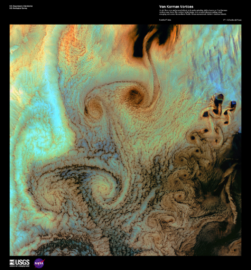
Von Karman Vortices As air flows over and around objects in its path, spiraling eddies, known as Von Karman vortices, may form. The vortices in this image were created when prevailing winds sweeping east across the northern Pacific Ocean encountered Alaska's Aleutian Islands.
This image can be found on Landsat 7 Path 79 Row 23-24, center: 53.1 N, 170.4 W.
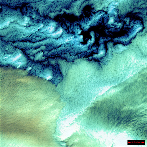
Aleutian Clouds These cloud formations were seen over the western Aleutian Islands. Their color variations are probably due to differences in temperature and in the size of water droplets that make up the clouds.
The Aleutian Clouds can be found on Landsat 7 WRS Path 91 Row 23, center: 53.10, 170.97.
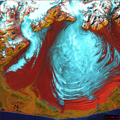
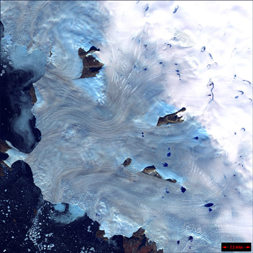
Malaspina Glacier The tongue of the Malaspina Glacier, the largest glacier in Alaska, fills most of this image. The Malaspina lies west of Yakutat Bay and covers 1,500 sq. MI (3,880 sq. km).
Malaspina can be found on Landsat 7 WRS Path 63 Row 18, center: 60.10, -141.78.
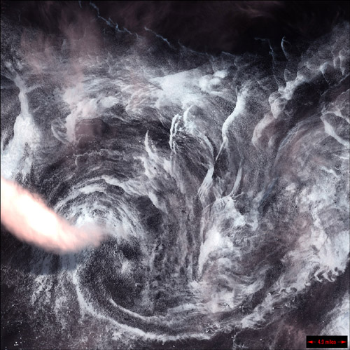
Whirlpool in the Air This image shows a spinning formation of ice, clouds, and low-lying fog off the eastern coast of Greenland.
This Whirlpool can be found on Landsat 7 WRS Path 232 Row 16, center: 62.86, -40.89.
Greenland Coast Along Greenland's western coast, a small field of glaciers surrounds Baffin Bay.
This portion of Greenland's Coast can be found on Landsat 7 WRS Path 20 Row 7, center: 74.71, -57.07
Yellowknife Wetlands Extensive wetlands lie near the town of Yellowknife, near the Great Slave Lake in northern Canada. The shallow lakes seen in this image have formed in grooves in the landscape that were carved by glaciers during the last Ice Age.
Yellowknife Wetlands can be found on Landsat 7 WRS Path 45 Row 16, center: 62.86, -111.97.
Akpatok Island Akpatok Island lies in Ungava Bay in northern Quebec, Canada. Accessible only by air, Akpatok Island rises out of the water as sheer cliffs that soar 500 to 800 feet (150 to 243 m) above the sea surface. The island is an import!ant sanctuary for cliff-nesting seabirds. Numerous ice floes around the island attract walrus and whales, making Akpatok a traditional hunting ground for native Inuit people.
Akpatok Island can be found on Landsat 7 WRS Path 15 Row 18, center: 60.10, -67.62.
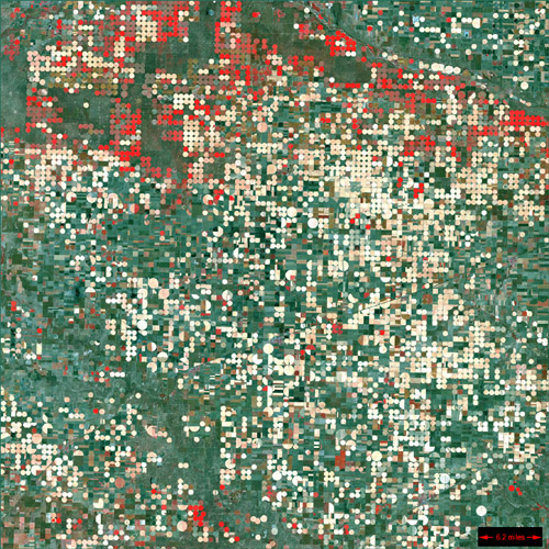
Garden City, Kansas Center pivot irrigation systems create red circles of healthy vegetation in this image of croplands near Garden City, Kansas.
Garden City can be found on Landsat 7 WRS Path 30 Row 34, center: 37.48, -100.51.
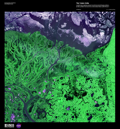
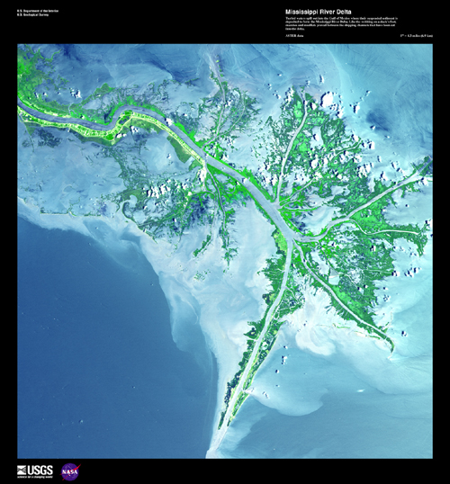
Mississippi River Delta Turbid waters spill out into the Gulf of Mexico where their suspended sediment is deposited to form the Mississippi River Delta. Like the webbing on a duck's foot, marshes and mudflats prevail between the shipping channels that have been cut into the delta.
This image can be found on ASTER Path 21 Row 40, center: 29.45 N, -89.28 W.
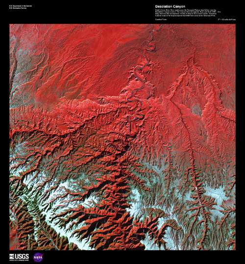
Desolation Canyon Utah's Green River flows south across the Tavaputs Plateau (top) before entering Desolation Canyon (center). The Canyon slices through the Roan and book Cliffs - two long, staircase-like escarpments. Nearly as deep as the Grand Canyon, Desolation Canyon is one of the largest unprotected wilderness areas in the American West.
This image can be found on Landsat 7 Path 37 Row 32, center: 40.3 N, 110.4 W.
Florida Everglades Spanning the southern tip of the Florida Peninsula and most of Florida Bay, Everglades National Park is the only subtropical preserve in North America. It contains both temperate and tropical plant communities, including sawgrass prairie, mangrove and cypress swamps, pinelands, and hardwood hammocks, as well as marine and estuarine environments. The park is known for its rich bird life, particularly large wading birds, such as the roseate spoonbill, wood stork, great blue heron, and a variety of egrets. It is also the only place in the world where alligators and crocodiles exist side by side.
The Everglades can be found on Landsat 7 WRS Path 15 Row 42, center: 26.00, -80.43.
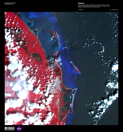
Cancun Known for its beaches and resort hotels, Cancun lies at the tip of Mexico's Yucatan Peninsula. Inland from this tourist mecca, however, lies a sparsely populated tropical scrub forest that shelters the ruins of ancient Mayan cities.
This image can be found on ASTER Path 18 Row 45, center: 21.25 N, 86.79 W.
Coahuila, Mexico This desolate landscape is part of the Sierra Madre Oriental mountain range, on the border between the Coahuila and Nuevo Leon provinces of Mexico.
Coahuila can be found on Landsat 7 WRS Path 28 Row 42, center: -26.00, -100.52.
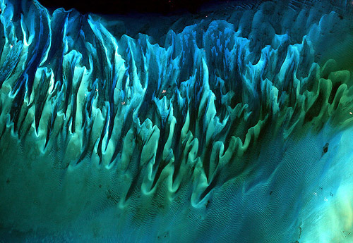
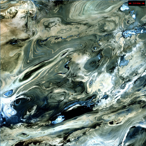
Ocean Sand, Bahamas Though the above image may resemble a new age painting straight out of an art gallery in Venice Beach, California, it is in fact a satellite image of the sands and seaweed in the Bahamas. The image was taken by the Enhanced Thematic Mapper plus (ETM+) instrument aboard the Landsat 7 satellite. Tides and ocean currents in the Bahamas sculpted the sand and seaweed beds into these multicolored, fluted patterns in much the same way that winds sculpted the vast sand dunes in the Sahara Desert.
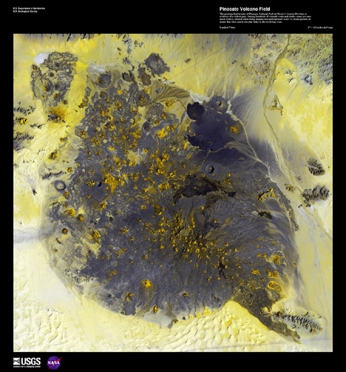
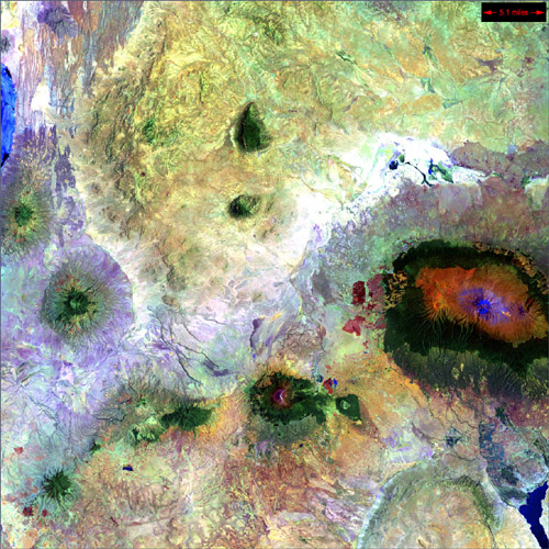
Pinacate Volcano Field The pockmarked terrain of Pinacate National Park in Mexico's Sonora Province is evidence of a violent past. Among hundreds of volcanic vents and cinder cones are rare maar craters, formed when rising magma met underground water to create pockets of steam that blew nearly circular holes in the overlying crust.
This image can be found on Landsat 7 Path 37 Row 38, center: 31.7 N, 112.9 W.
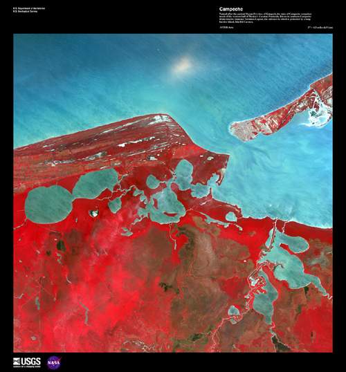
Campeche Named after the ancient Mayan Province of Kimpech, the state of Campeche comprises much of the western half of Mexico's Yucatan Peninsula. Rivers in southern Campeche drain into the immense Terminos Lagoon, the entrance to which is protected by a long barrier island, Isla Del Carmen.
This image can be found on ASTER Path 21 Row 47, center: 18.57 N, 91.97 W.
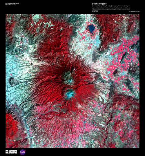
Colima Volcano Snow-capped Colima Volcano, the most active volcano in Mexico, rises abruptly from the surrounding landscape in the state of Jalisco. Colima is actually a melding of two volcanoes, the older Nevado de Colima to the north and the younger, historically more active Volcan de Colima to the south. Legend has it that gods sit atop the volcano on thrones of fire and ice.
This image can be found on ASTER Path 29 Row 46, center: 19.57 N, 103.60 W.
ASIA & THE MIDDLE EAST
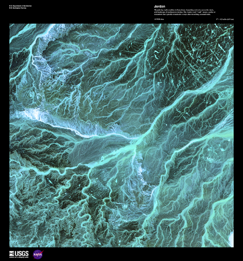
Jordan Meandering wadis combine to form dense, branching networks across the stark, arid landscape of southeastern Jordan. The Arabic word "wadi" means a gully or streambed that typically remains dry except after drenching, seasonal rains.
This image can be found on ASTER Path 173 Row 39, center: 30.93 N, 37.03 E.
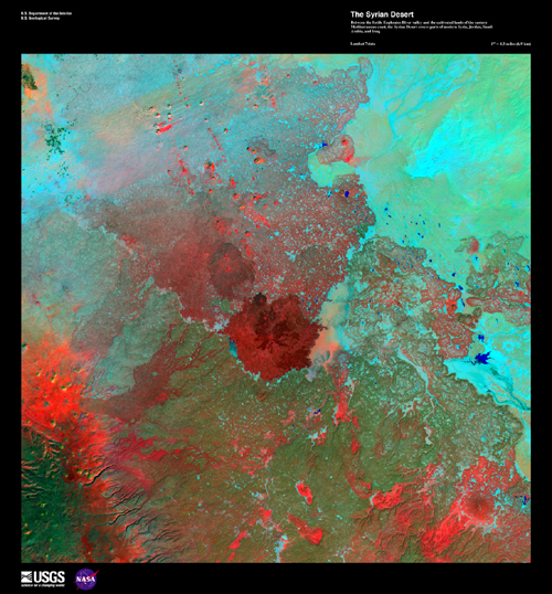
Syrian Desert Between the fertile Euphrates River valley and the cultivated lands of the eastern Mediterranean coast, the Syrian Desert covers parts of modern Syria, Jordan, Saudi Arabia, and Iraq.
This image can be found on Landsat 7 Path 173 Row 37, center: 33.2 N, 37.3 E.
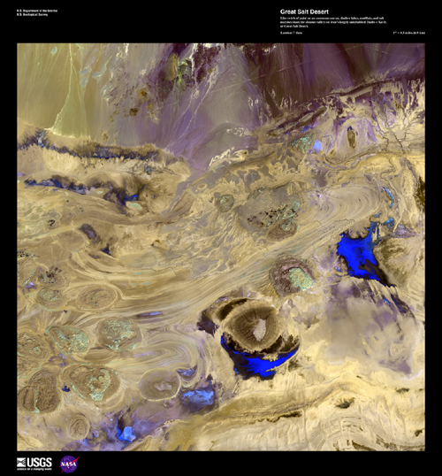
Great Salt Desert Like swirls of paint on an enormous canvas, shallow lakes, mudflats, and salt marshes share the sinuous valleys on Iran's largely uninhabited Dasht-e Kavir, or Great Salt Desert.
This image can be found on Landsat 7 Path 163 Row 36, center: 34.6 N, 53.2 E.
Dasht-e Kevir The Dasht-e Kevir, or valley of desert, is the largest desert in Iran. It is a primarily uninhabited wasteland, composed of mud and salt marshes covered with crusts of salt that protect the meager moisture from completely evaporating.
Dasht-e Kevir can be found on Landsat 7 WRS Path 162 Row 36, center: 34.62, 54.71.
Iraqi Emplacement In an area north of the city of Al-Basrah, Iraq, which borders Iran, a former wetland has been drained and walled off. Now littered with minefields and gun emplacements, it is a staging area for military exercises.
This emplacement can be found on Landsat 7 WRS Path 166 Row 39, center:30.31, 47.36.
Konari, Iran The Mand River and the small town of Konari nestle in the Zagros Mountains in western Iran.
Konari can be found on Landsat 7 WRS Path 163 Row 40, center: 28.87, 51.62.
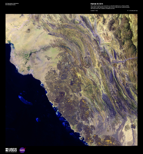
Harrat Al Birk Dark-colored volcanic cones sprout from an ancient lava field known as Harrat Al Birk along Saudi Arabia's Red Sea coastline. Many such lava fields dot the Arabian Peninsula and range in age from 2 million to 30 million years old.
This image can be found on Landsat 7 Path 168 Row 47, center: 18.8 N, 41.5 E.
Sulaiman Mountains The Sulaiman Mountains are a major geological feature of Pakistan and one of the bordering ranges of the Indian subcontinent.
The Sulaiman Mountains can be found on Landsat 7 WRS Path 152 Row 37/38/39, center: 31.75, 69.37.
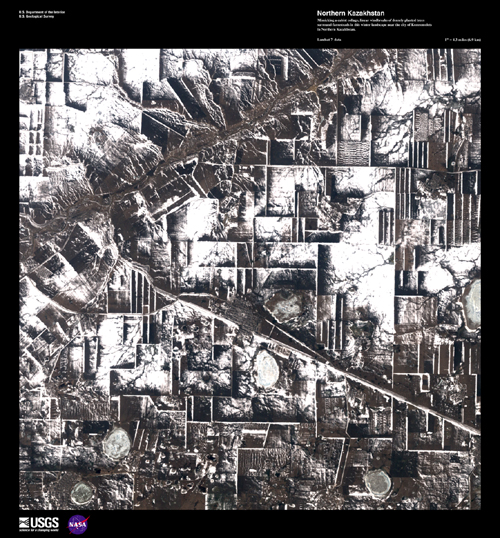
Northern Kazakhstan Mimicking a cubist collage, linear windbreaks of densely planted trees surround farmsteads in this winter landscape near the city of Komsomolets in Northern Kazakhstan.
This image can be found on Landsat 7 Path 161 Row 23, center: 53.1 N, 62.9 E.
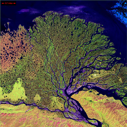
Lena Delta The Lena River, some 2,800 miles (4,400 km) long, is one of the largest rivers in the world. The Lena Delta Reserve is the most extensive protected wilderness area in Russia. It is an import!ant refuge and breeding grounds for many species of Siberian wildlife.
The Lena Delta can be found on Landsat 7 WRS Path 131 Row 8/9, center: 72.21, 126.15.
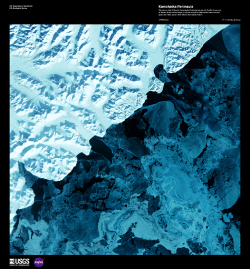
Kamchatka Peninsula The eastern side of Russia's Kamchatka Peninsula juts into the Pacific Ocean west of Alaska. In this winter image, a volcanic terrain is hidden under snow-covered peaks and valley glaciers feed blue ice into coastal waters.
This image can be found on ASTER Path 96 Row 18, center: 60.03 N, 167.68 E.
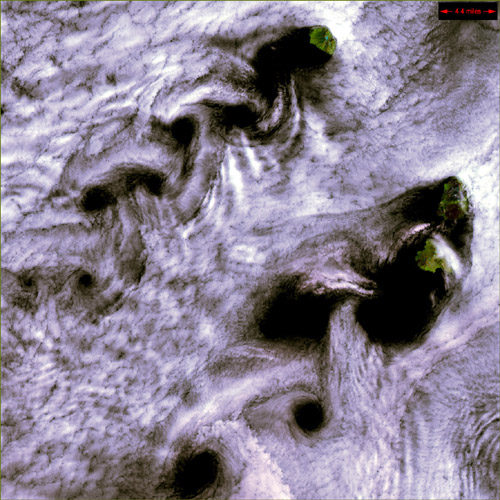
Karman Vortices near Broutona These Karman vortices formed over the islands of Broutona, Chirpoy, and Brat Chirpoyev ("Chirpoy's Brother"), all part of the Kuril Island chain found between Russia's Kamchatka Peninsula and Japan.
Broutona can be found on Landsat 7 WRS Path 103 Row 27/28, center: 46.03, 149.54.
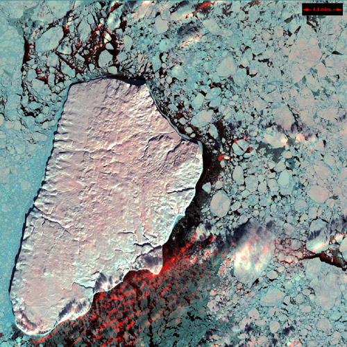
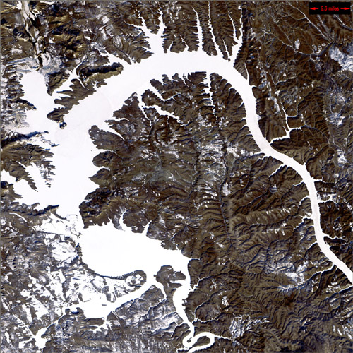
Dragon Lake, Siberia Nicknamed "Dragon Lake," this body of water is formed by the Bratskove Reservoir, built along the Angara River in southern Siberia, near the city of Bratsk. This image was acquired in winter, when the lake is frozen.
Dragon Lake can be found on Landsat 7 WRS Path 136 Row 21, center: 55.92, 102.93.
Mayn River, Siberia The Mayn River, seen here with what is thought to be a portion of the Anadyr River, flows through the far northeastern corner of Siberia.
The Mayn River can be found on Landsat 7 WRS Path 96 Row 15, center: 64.23, 170.37.
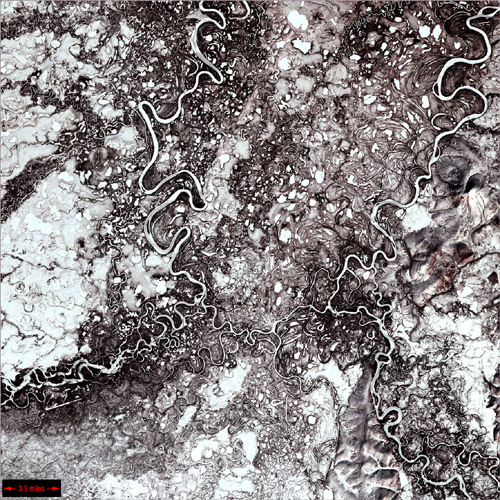
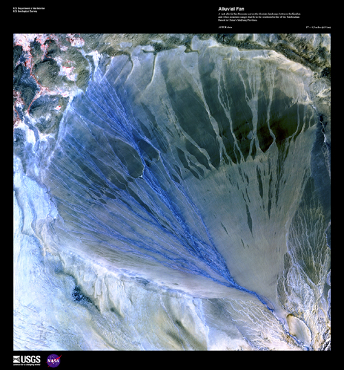
Alluvial Fan, China A vast alluvial fan blossoms across the desolate landscape between the Kunlun and Altun mountain ranges that form the southern border of the Taklimakan Desert in China's XinJiang Province.
This image can be found on ASTER Path 143 Row 34, center: 37.43 N, 84.30 E.
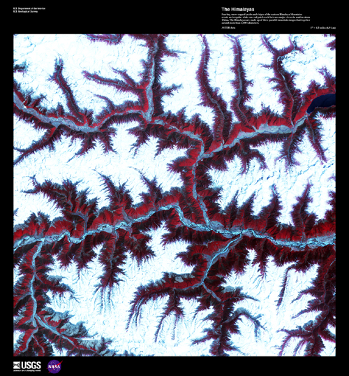
The Himalayas Soaring, snow-capped peaks and ridges of the eastern Himalayas Mountains create an irregular white-on-red patchwork between major rivers in southwestern China. The Himalayas are made up of three parallel mountain ranges that together extend more than 2900 kilometers.
This image can be found on ASTER Path 136 Row 39, center: 29.93 N, 93.62 E.
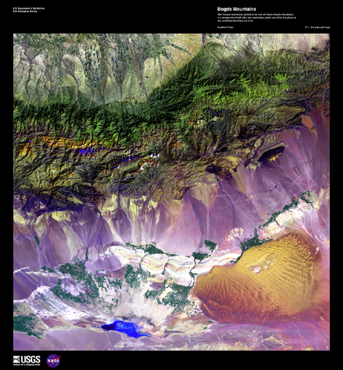
Bogda Mountains The Turpan Depression, nestled at the foot of China's Bogda Mountains, is a strange mix of salt lakes and sand dunes, and is one of the few places in the world that lies below sea level.
This image can be found on Landsat 7 Path 141 Row 30, center: 43.2 N, 89.8 E.
Edrengiyn Nuruu The Edrengiyn Nuruu forms a transition zone between the Mongolian steppes to the north and the arid deserts of northern China to the south.
Edrengiyn Nuruu can be found on Landsat 7 WRS Path 136 Row 29, center: 44.61, 98.03.
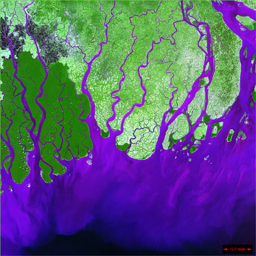
Ganges River Delta The Ganges River forms an extensive delta where it empties into the Bay of Bengal. The delta is largely covered with a swamp forest known as the Sunderbans, which is home to the Royal Bengal Tiger.
The Ganges River Delta can be found on Landsat 7 WRS Path 137 Row 44, center: 23.12, 90.37.
EUROPE
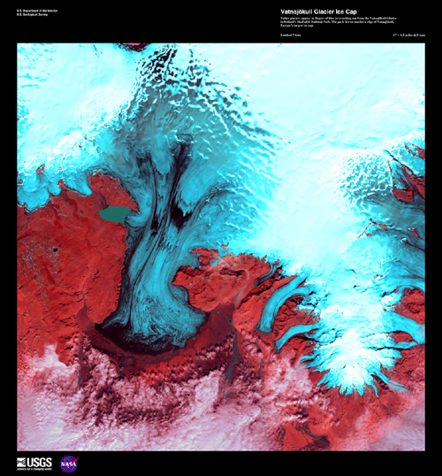
Vatnajökull Glacier Ice Cap Valley glaciers appear as fingers of blue ice reaching out from the Vatnajökull Glacier in Iceland's Skaftafell National Park. The park lies on the southern edge of Vatnajökull, Europe's largest icecap.
This image can be found on Landsat 7 Path 217 Row 15, center: 64.2 N, 16.6 W.
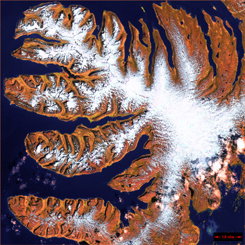
West Fjords The West Fjords are a series of peninsulas in northwestern Iceland. They represent less than one-eighth the country's land area, but their jagged perimeter accounts for more than half of Iceland's total coastline.
The West Fjords can be found on Landsat 7 WRS Path 222 Row 14, center: 65.59, -23.07.
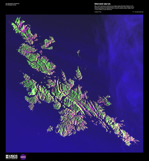
Shetland Islands Like a many-faceted jewel fashioned in an indigo setting, the Shetland Islands lie 210 kilometers north of the Scottish mainland in the North Atlantic Ocean. Despite their 60 degree north latitude, the Shetlands enjoy a relatively temperate climate thanks to the warming influence of the Gulf Stream.
This image can be found on Landsat 7 Path 205 Row 18, center: 60.1 N, 1.2 W.
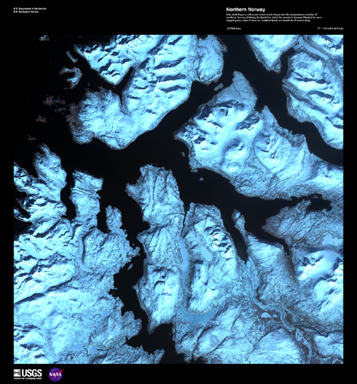
Northern Norway Like dark fingers, cold ocean waters reach deeply into the mountainous coastline of northern Norway, defining the fjords for which the country is famous. Flanked by snow-capped peaks, some of these ice-sculpted fjords are hundreds of meters deep.
This image can be found on ASTER Path 198 Row 11, center: 69.4 N, 18.4 E.
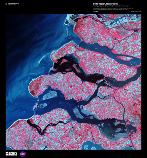
Delta Region, Netherlands Along the southern coast of the Netherlands, sediment-laden rivers have created a massive delta of islands and waterways in the gaps between coastal dunes. After unusually severe spring tides devastated this region in 1953, the Dutch built an elaborate system of dikes, canals, dams, bridges, and locks to hold back the North sea.
This image can be found on ASTER Path 199 Row 24, center: 51.70 N, 3.97 E.
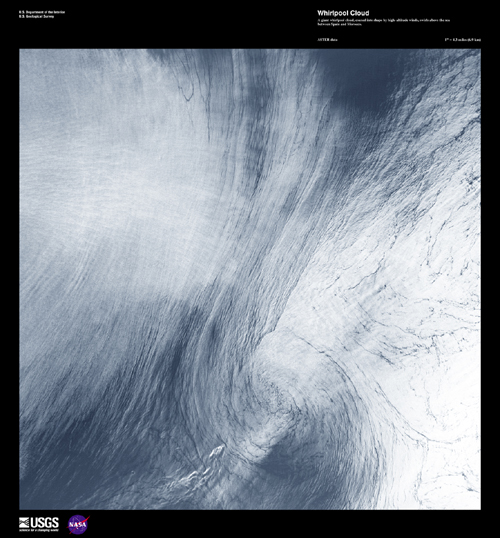
Whirlpool Cloud A giant whirlpool cloud, coaxed into shape by high-altitude winds, swirls above the sea between Spain and Morocco.
This image can be found on ASTER Path 200 Row 35, center: 35.67 N, 3.71 W.
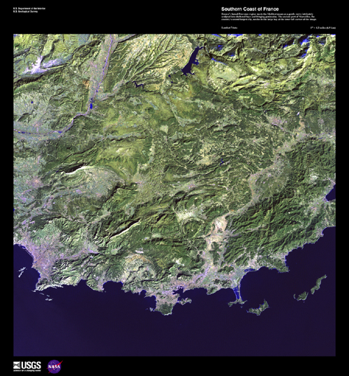
Southern Coast of France France's famed Provence region meets the Mediterranean as a gentle curve intricately sculpted into sheltered bays and fringing peninsulas. The ancient port of Marseilles, the country's second largest city, nestles in the large bay at the lower left corner of the image.
This image can be found on Landsat 7 Path 195 Row 30, center: 43.2 N, 6.4 E.
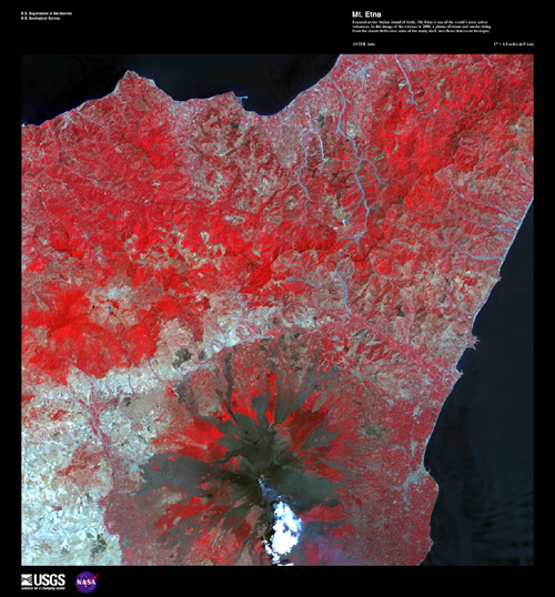
Mt. Etna Located on the Italian island of Sicily, Mt. Etna is one of the world's most active volcanoes. In this image of the volcano in 2001, a plume of steam and smoke rising from the crater drifts over some of the many dark lava flows that cover its slopes.
This image can be found on ASTER Path 188 Row 34, center: 37.94 N, 15.06 E.
Volga River Delta Where the Volga River flows into the Caspian Sea, it creates an extensive delta. The Volga Delta is comprised of more than 500 channels, and sustains the most productive fishing grounds in Eurasia.
The Volga Delta can be found on Landsat 7 WRS Path 168 Row 28, center: 46.03, 49.11.
AFRICA
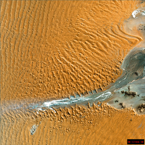
Sahara Desert Massive sand dunes have been swept around and between rock outcroppings in the barren Libyan Desert. Only a handful of oases lie scattered across this especially arid section of the vast Sahara Desert.
This image can be found on ASTER Path 179 Row 45, center: 22.31 N, 24.79 E.
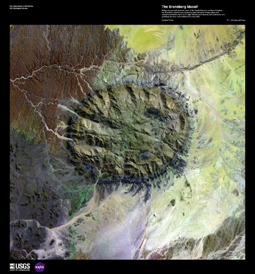
Brandberg Massif Rising unexpectedly from the heart of the Namib Desert in northern Namibia, the Brandberg Massif is an exhumed granite intrusion. Unique plant and animal communities thrive in its high-altitude environment, and prehistoric cave paintings decorate walls hidden in its steep cliffs.
This image can be found on Landsat 7 Path 180 Row 75, center: 21.7 N, 14.1 E.
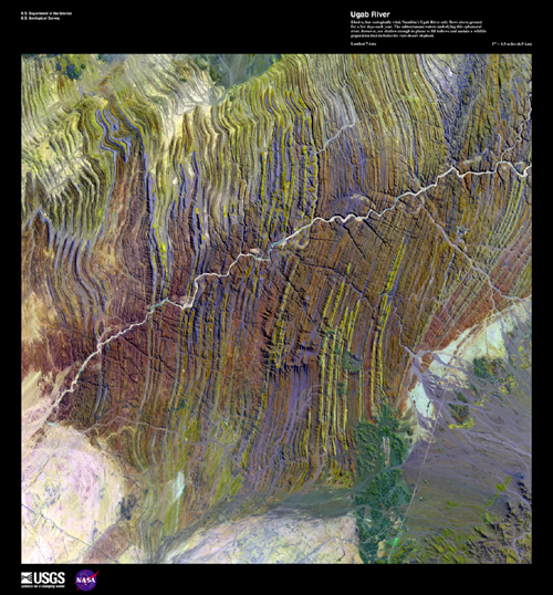
Ugab River Elusive, but ecologically vital, Namibia's Ugab River only flows above ground for a few days each year. The subterranean waters underlying this ephemeral river, however, are shallow enough in places to fill hollows and sustain a wildlife population that includes the rare desert elephant.
This image can be found on Landsat 7 Path 180 Row 75, center: 21.7 N, 14.1 E.
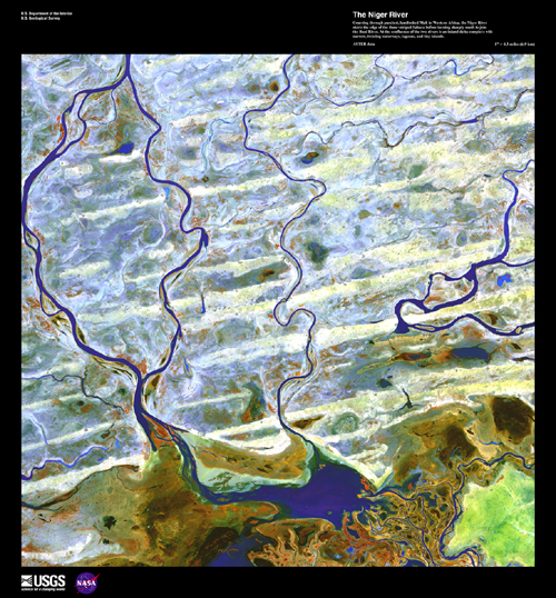
Niger River, Massina Mali Coursing through parched, landlocked Mali in Western Africa, the Niger River skirts the edge of the dune-striped Sahara before turning sharply south to join the Bani River. At the confluence of the two rivers is an inland delta complete with narrow, twisting waterways, lagoons, and tiny islands.
This image can be found on ASTER Path 197 Row 49, center: 15.52 N, 4.10 W.
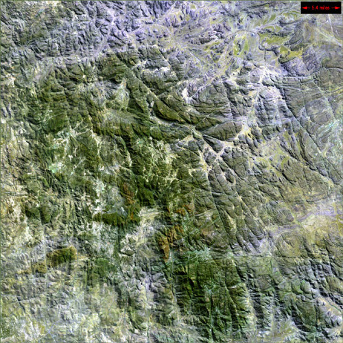
Atlas Mountains These are the Anti-Atlas Mountains, part of the Atlas Mountain range in southern Morocco, Africa. The region contains some of the world's largest and most diverse mineral resources, most of which are still untouched.
The Atlas Mountains can be found on Landsat 7 WRS Path 201 Row 39, center: 30.31, -6.74.
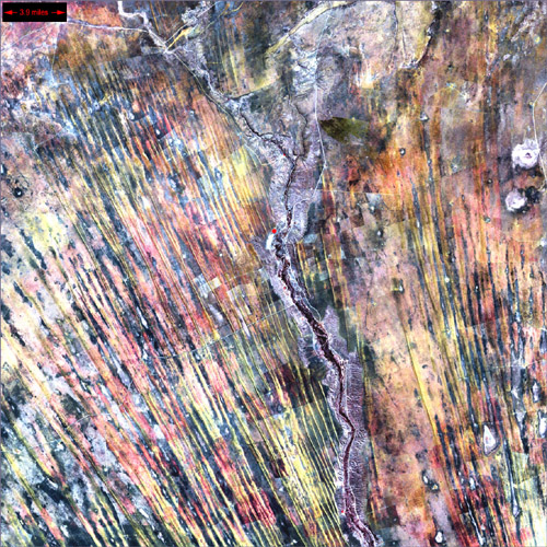
Ghadamis River This scar on an arid landscape is the dry riverbed of the Ghadamis River in the Tinrhert Hamada Mountains near Ghadamis, Libya.
The Ghadamis River can be found on Landsat 7 WRS Path 189 Row 39, center: 30.31, 11.83.
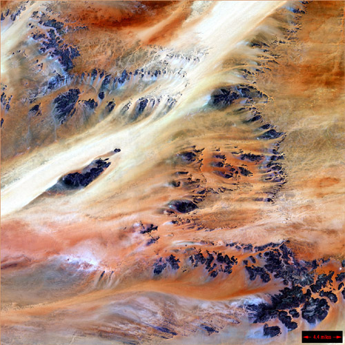
Terkezi Oasis A series of rocky outcroppings are a prominent feature of this Sahara Desert landscape near the Terkezi Oasis in the country of Chad.
The Terkezi Oasis can be found on Landsat 7 WRS Path 180 Row 47, center: 18.79, 22.92.
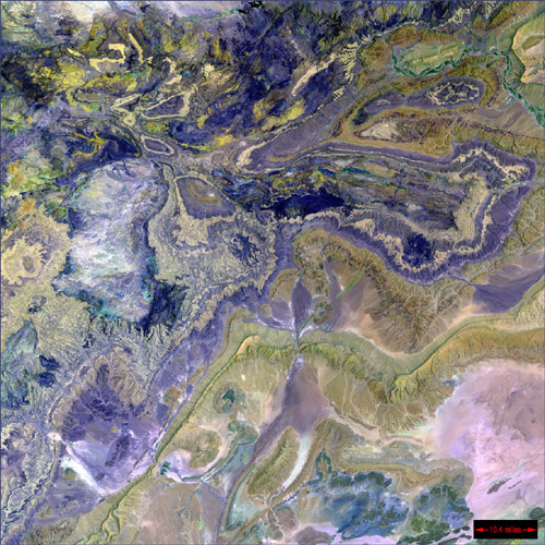
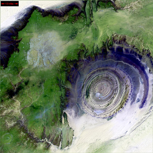
Richat Structure The so-called Richat Structure is a geological formation in the Maur Adrar Desert in the African country of Mauritania. Although it resembles an impact crater, the Richat Structure formed when a volcanic dome hardened and gradually eroded, exposing the onion-like layers of rock.
The Richat Structure can be found on Landsat 7 WRS Path 203 Row 45, center: 21.68, -11.94.
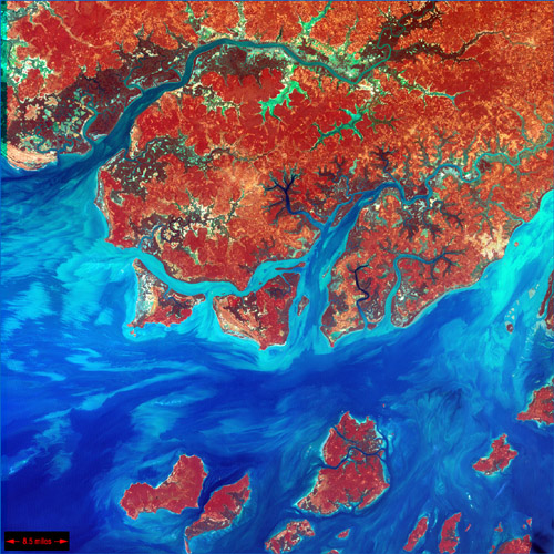
Guinea-Bissau Guinea-Bissau is a small country in West Africa. Complex patterns can be seen in the shallow waters along its coastline, where silt carried by the Geba and other rivers washes out into the Atlantic Ocean.
Guinea-Bissau can be found on Landsat 7 WRS Path 204 Row 52, center: 11.57, -15.77.
Kilimanjaro, Tanzania Portions of Kenya and Tanzania, Africa, can be seen in this image. The peak of Kilimanjaro is on the right; the mountain is flanked by the plains of Amboseli National Park to the north and the rugged Arusha National Park to the south and west.
Kilimanjaro can be found on Landsat 7 WRS Path 168 Row 62, center: -2.89, 36.76.
The Optimist, Kalahari Desert, Namibia On the edge of the Kalahari Desert in Namibia, sand dunes are encroaching onto once-fertile lands in the north. Healthy vegetation appears red in this image; in the center, notice the lone red dot. It is the result of a center-pivot irrigation system, evidence that at least one optimistic farmer continues to work the fields despite the approaching sand.
The Optimist can be found on Landsat 7 WRS Path 177 Row 76, center: -23.12, 18.37.
Namib Desert, Namibia Namib-Naukluft National Park is an ecological preserve in Namibia's vast Namib Desert. Coastal winds create the tallest sand dunes in the world here, with some dunes reaching 980 feet (300 meters) in height.
The Namib Desert can be found on Landsat 7 WRS Path 179 Row 77, center: -24.56, 14.93.
Namaqualand, South Africa Namaqualand in South Africa is known as the "gem of the Northern Cape." Portions of this area were turned into a national park in 1999, to preserve the abundant wildlife and brilliant wildflowers native to the area.
Namaqualand can be found on Landsat 7 WRS Path 176 Row 81, center: -30.31, 18.12.
http://earthasart.gsfc.nasa.gov/
아~ 정말 너무 아름답네요 큰사진으로 보니 정말 숨이 막혀요 아름다워서..
|

출처: 쿨하게 가슴은 뜨겁게 원문보기 글쓴이: 미치고싶을때
