|
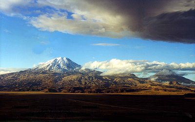
Mount Ararat 1999 - Courtesy Rob
Michelson
Mount Ararat is located in Eastern Turkey on the borders of Iran, Armenia
(formerly U.S.S.R.), and Nachivan. This volcanic mountain rises 5,165 meters or
16,945 feet high above the plains and is the highest location in the ancient
kingdom of Urartu, a region which covered thousands of square miles. Ararat is
the bastardized name of Urartu from the Hebrew Torah
written by Moses (c. 1450 BC) which only included the consonants "rrt".
아라랏산은 이란과알메니아의 국경 터키 동부에 위치
이 화산은 5165미터
높이로 우라르투왕국엣 최고로 높은 지대에 위치 아라랏은 모세오경에서 비롯되었는데 원모세오경은 자음으로만
기록 거기에는 "rrt"의 자음만 나타남 그런데 이것은 우라르투란 말이며 아라랏은 잘못 번역된 것
However,
the translators of the Bible replaced the "rrt" with the later name, "Ararat."
The Assyrians wrote about battles against the Urartian tribes from the
thirteenth century BC until the sixth century BC when Urartu was destroyed by
the Medes. The name Urartu then vanished from history and was replaced by Ararat
and Armenia in the vicinity as well as in Bible translations in English, etc.
앗수르인들은 비시 13세기부터 비시 6세기까지의 우라르트와의 전쟁기록을 남겼는데 비시 6세기경
메데에 의해 그 왕국은 멸망
우라르투라는 명칭은 그래서 역사에서
사라졌고 대신 비슷한 아라랏과 알메니아로 대치되었다 성경 영역본에서 보는 것처럼
As
history went on in the first and second millenia AD, the mountain became known
as Ararat and the region as Armenia. Many people believe that Mount Ararat is
the place where Noah's Ark landed but the Bible does not state this. It simply
says that the boat landed in the Urartian mountains, of which there are
hundreds, although Ararat is the highest. Since Mount Ararat is the highest
location in Urartu, some people throughout history have jumped to the unproven
conclusion that it was the landing place and promoted that concept as a regional
tradition.
Mount Ararat may be the largest single-mass or volume mountain in the world
as it is huge (one really has to see it in person to appreciate its immensity)
and rises to 17,000 feet from the plains surrounding it at 2,000-3,000 feet
while most other large mountains are in a mountain range with less differential
and base circumference. Ararat has only a few native trees growing on it in
Ahora village and several small forests on Little Ararat. Views differ as to
whether Ararat formed much of its size after the flood (post-flood) or during
the flood as some geologists like Seventh Day Adventist Clifford Burdick Ph.D.
have claimed to find pillow lava (lava spewed into water) around the 14,000-foot
level. Some geologists claim that cylindrical mountains like Little Ararat show
that it is a post-flood mountain. There are also claims of fossils and
sedimentary layers on Greater Ararat but these claims have not been backed up
with evidence as of this date although there are fossils near Ararat. From
14,000 feet to 17,000 feet, much of the lava is covered by an ice cap which is
about 17 square miles in size and is up to 300 feet deep. As computed by ArcImaging, the coordinates that cover the ice cap
area on Mount Ararat are N 39 degrees 41' to N 39 degrees 44', E 44 degrees 15'
30" to E 44 degrees 19' 30". The area of this rectangle is about 31.6 square
kilometers.
Since the upper reaches of this volcanic mountain are covered with broken
lava rock everywhere and are currently extremely difficult to ascend or descend,
its present state makes it a poor location for Noah's Ark to land and for all
the animals to easily descend. Yet, Mount Ararat has the bulk of the purported
eyewitnesses of the boat-like structure, especially since 1850. These "alleged"
eyewitnesses are the only reason why the search should continue on the mountain.
Given the extensive research which has taken place on Mount Ararat, it seems
fair to say that if Noah's Ark ever survived into modern times and is somewhere
on Ararat, there are few new places remaining on the mountain to search. There
have been many expeditions, accounts, alleged sightings, anomalies, and claims
of discovery involving Mount Ararat. What is lacking is any scientific evidence
or photo that shows that Noah's Ark exists today. However, one should also
consider the possibility that Noah's Ark landed on Mount Ararat and was
subsequently destroyed, which is the possibility alluded to in the article Even
If Noah뭩 Ark Is Not Proven, Noah뭩 Ark Still Could Have Landed On Mount
Ararat.
Given
all the ground and aerial expeditions (and one with sophisticated mapping
capabilities), one should surmise that if the remains of Noah's Ark are indeed
on Mount Ararat, they are not in plain view; if the boat is there, it must be
buried. There have been 2 attempts that used sub-surface Radar (Ground
Penetrating Radar - GPR) technology on Mount Ararat to look under the ice. The
1988 Willis expedition and the 1989 Aaron/Garbe/Corbin expedition used GPR. The
1988 Willis expedition successfully surveyed the eastern summit plateau and the
saddle area between the two peaks, concluding there were no Ark remains under
the ice. The 1989 expedition was not as successful as the preceding year, where
a less-capable GPR system was used in temperate (melting) ice cap conditions on
the western plateau of Mount Ararat. However, they were able to determine the
ice depth on the western plateau and scale the size of the Ark.
If
the remains of Noah's Ark were in moving ice on Mount Ararat (there is only one
legitimate glacier, the Black Glacier, though there are other moving ice flows
like the so-called Parrot Glacier), the Ark would have been ground to bits.
ArcImaging contends that until the entire
mountain has been adequately "sub-surface" surveyed using the latest remote
sensing technology, some people such as the alleged eyewitnesses contended that
the Ararat ice cap contains the remains of Noah's Ark since about 90% of the
supposed eyewitnesses claim that the boat was sticking out of the ice even
though the explorers over the past 50 years did not see the same boat-like
structure. |

